La Palma is a volcanic island in the form of a caldera. It is one of the seven main Canary Islands. It is located in the Atlantic Ocean off the west coast of Africa. The entire island was declared a UNESCO World Biosphere Reserve of La Palma in 2002. The island is of volcanic origin and is 3 to 4 million years old. It rises from the seabed to a total height of almost 7 km. The base of the volcano is located approximately 4,000 meters below sea level and the highest peak of the island, Roque de los Muchachos, rises to a height of 2,426 meters above sea level.
La Palma is currently the most volcanically active island of the Canary Islands. The last eruption on this island dates back to September 2021, the previous volcanic activity was in 1971, when the Teneguia volcano, located at the southern end of the island, erupted. (source: Wikipedia)
Why La Palma
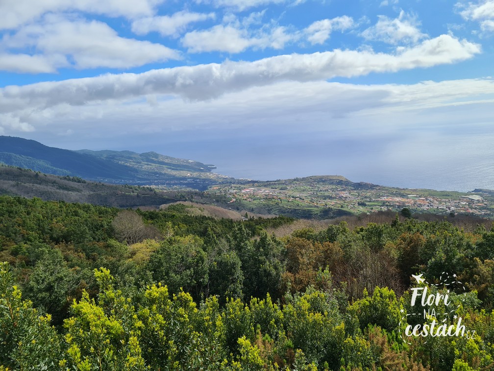
La Palma is the fifth largest island of the Canary Islands, lies in their western part. The island is paradise for hiking lovers. You'll fall in love with the mountains, hills, misty laurel forest and volcanoes here. Especially the volcanoes.
You won't find beaches with golden sand here, because the winds from the Sahara don't blow here, but you can enjoy nature and the entire island in general in every season.
Getting to La Palma
The journey to La Palma can be a bit complicated and expensive from the Czech Republic. In 2022, when we went there, there were no direct flights from the Czech Republic, and this will continue to be the case in 2024. It is possible with a transfer and the prices are quite high.
That's why we'd better look around at nearby airports, I think it will be more interesting and more profitable. As always, I will help you with the search google flights or skyscanner. I describe how to book flights on the page https://florinacestach.cz/tip_letenky/, so take a look at it. Here too, you just search for a flight ticket in search engines and you then buy directly on the airline's website. I don't need to talk about the advantages of such a purchase again. We flew during Covid, so we had to reschedule the flight twice, and dealing with it directly with the airline was completely hassle-free.
The best option for us (in 2022) was a direct flight with EasyJet from Berlin. By car, you can get from Prague to Berlin in three hours, parking at the airport is easy, and in four it's a great deal.
Budget (in 2022)
- Total airfare approx. 4,200 CZK (airfare, 2x flight transfers, additional suitcase purchase)
- Diesel Prague – Berlin – Prague 483 CZK
- Parking for a week in Berlin at the airport 365 CZK
- Car rental on La Palma 960 CZK
- Accommodation for a week via airbnb 3,700 CZK.
Not even 10 thousand in total. Which is less than the flight ticket from Prague itself costs. And this is already including the discount. Of course, you have to add some gas and food. But Lidl or HiperDino will do it here. And the prices? Somewhat cheaper, some more expensive than here. All in all, not too bad. It depends on how much you splurge and how much Prosecco you buy (or mandarin juice at Lidl, which is TOP!).
Car and accommodation
We visited La Palma at the beginning of April 2022. They are here all year round temperatures above 20 degrees and there is not much rainfall. We had reserved a car a long time in advance, so we picked it up at the airport upon arrival. There are plenty of rental companies here, we used the previously tried Cicar. In general, you don't need a big car to travel around the Canary Islands. The roads to tourist attractions are often narrow and winding, so you won't be driving very fast anyway.
We booked accommodation through Airbnb, an apartment in the centre of the capital city of Santa Cruz de la Palma. Two bedrooms, two bathrooms, kitchenette. More than enough.
La Palma: Talking about the island
About 500,000 years ago, the original Taburiente volcano collapsed with giant landslides and was thus formed Caldera de Taburiente. It is now the foundation of the island. It then rises above the Caldera to a height of 2,426 meters the highest peak of the island Roque de los Muchachos. Volcanic activity has created several other volcanoes that stretch the entire length of the island. La Palma is currently the most volcanically active island of the Canary Islands.
Even though La Palma may seem like a smaller island on the map, there are many places to see and explore here. Nature is beautiful here.. Plus, if you're lucky (or unlucky, as the case may be) to be here during the Cumber Vieja eruption and you're encountering lava everywhere, then that just enhances the whole island experience.
You could easily be here for 10 days and still have places to go and things to discover. Not only Martian landscape around volcanoes, but also laurel cloud forest, mountain peaks, the walls of the Caldera Taburiente, or maybe black beaches and swimming in the ocean. Everything is possible.
Lots of tips I also have our complete itinerary, including marked places and routes on the maps. wrote down to your guide, which I will be happy to send you (and for free). It will definitely help you with planning your trip, so don't forget to pack it.
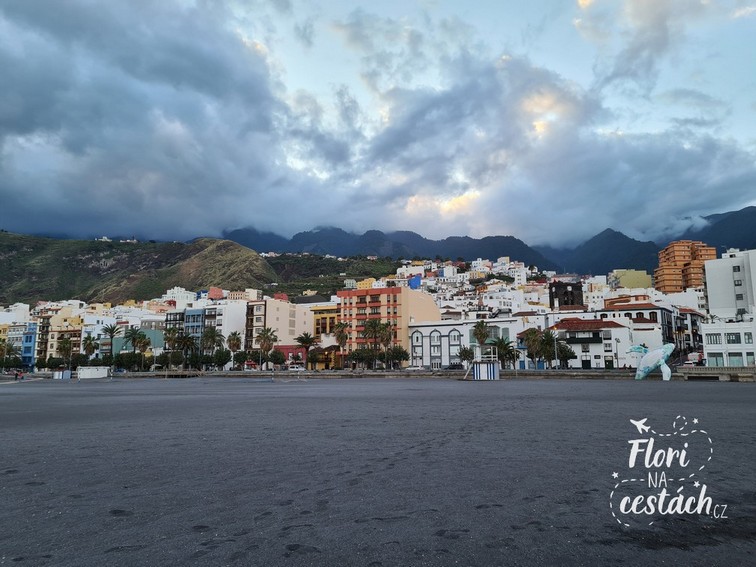
Santa Cruz de la Palma
Santa Cruz de la Palma is located on the east coast of the Atlantic Ocean, roughly in the middle of the island. It is pleasant town with a center full of various shops, restaurants and bars. You can easily buy food in a supermarket, there are several in the center and you can get everything you need. In addition, you can also go to the black sand beach, which is also right in the center. Unfortunately, we didn't have time for that.
Cumbre Vieja
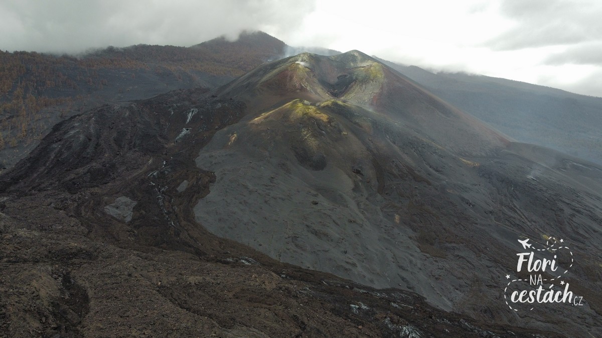
When you arrive in La Palma 3 months after Cumbre Vieja ends its eruption and you know it's everywhere fresh lava, so it's clear that the first path leads right here. To the site of the recent eruption. From Santa Cruz de la Palma we went to the other side of the island. Via El Paso to Elpalme Tajuya, where there is a viewpoint Tajuya Viewpoint. It is a spot in front of the local church, from which there is a view of newly formed crater the stratovolcano Cumbre Vieja.
By the way, the stratovolcano Cumbre Vieja occupies the entire southern third of the island and is made up of dozens of craters, domes and parasitic cones. The volcano is the cause of all eruptions on the island for the last 7,000 years and is the most active volcano in the Canary Islands. The last eruption took place between September 19 and December 13, 2021, which was the longest eruption in the last 500 years and ended a 50-year period of inactivity. The lava flow destroyed over 2,100 houses (villages of El Paraíso, La Laguna and Todoque), 66 km of roads, and covered an area of 9 km². Black volcanic ash covered an area of 55 km².
Get to the lava
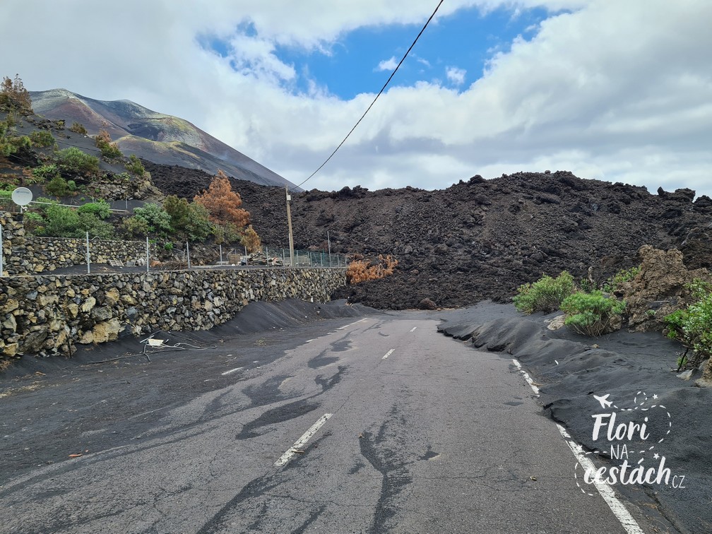
But who would be satisfied with a view, right? Of course you want to take a look as close as possible and literally touch the new crater. We left the car in the parking lot by the church and just walked through the streets towards up to the new cone. Along the way, we passed countless volunteers who were helping to clean houses and remove volcanic ash deposits to make the houses habitable again. Black everywhere, dust everywhere. On the one hand, a sad sight, on the other, fascinating.
We reached the place where the lava flow was flowing. After the eruption, there was lava river estimated to be more than three meters high, in some places up to three kilometers wide. It's incredible how strong and powerful nature is.
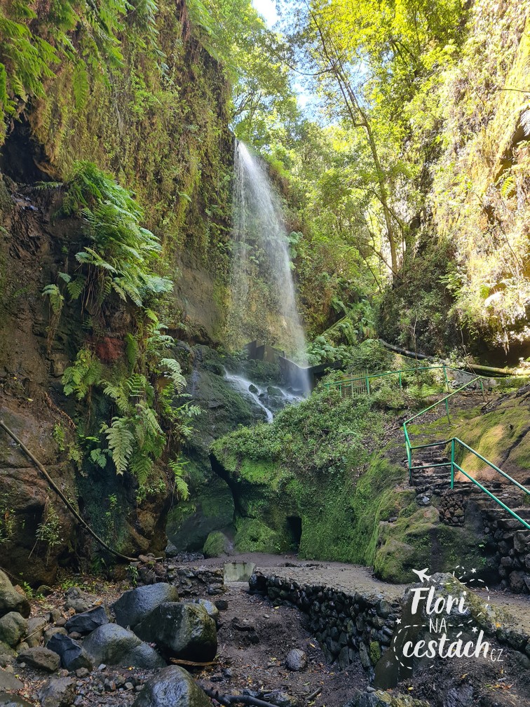
Waterfall of Colors
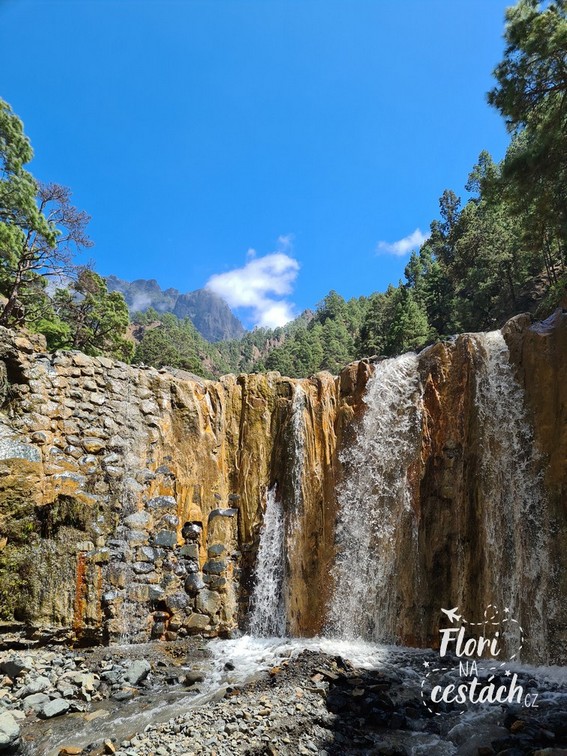
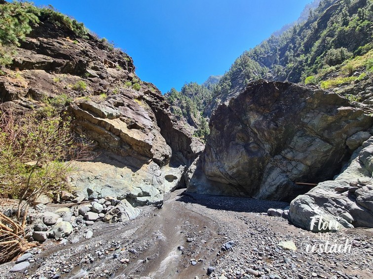
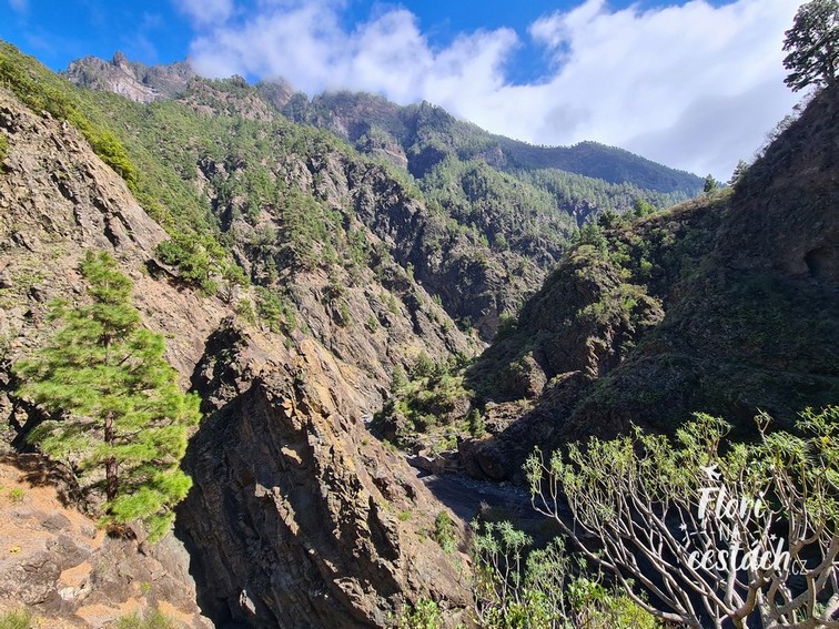
Another day, another adventure. This time we headed to colorful waterfall Cascada de Colores. However, it is not a natural monument, as it might seem, nor was it built as a tourist attraction. It was built in the 1960s wall, which was supposed to hold water from the Caldera. The yellow and orange shades are due to the iron content dissolved in the waters of the canyon. The water here is among the most iron-rich on the entire island of La Palma. The green tones are then provided by aquatic algae and mosses. Together they create a palette of shades, which changes throughout the year and depending on the strength of the waterfall's flow.
Even the path to the waterfall is very interesting and one could say that in a way unforgettable and experiential. By car you can reach the parking lot (marked on the map as Estacionamiento de La Caldera de Taburiente), from where the tourist route begins.
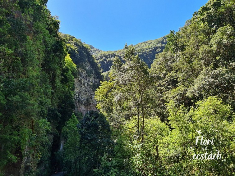
We passed the sign that warned that the route was closed and set off. along the riverbed of Barranco de las Angustias. You walk along the river (you definitely need track shoes, ideally waterproof ones), you jump from stone to stone, sometimes you turn away from the river and climb up the hill, then you go down to the river again. It's about 5 km. The whole time you enjoy the surroundings with amazing nature and the vertical walls of the Caldera de Taburiente.
Even though it might seem like it's one of the tourist attractions, we only met a few other groups of people on the entire trip there and back.
When we arrived at the waterfall, we had it to ourselves, so we even had a shower in it. Just be careful, there are stones flying from it here and there.
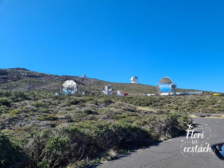
Roque de los Muchachos
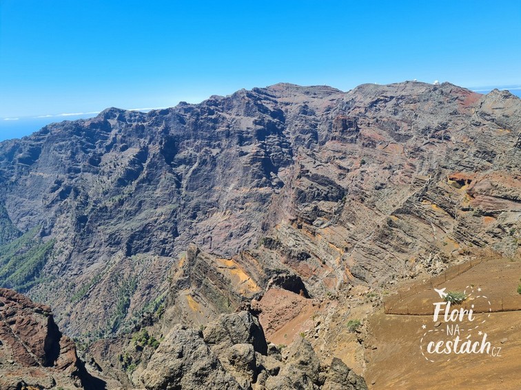
The highest peak of the island rises to a height of 2,426 meters. You can easily get to the top by car on a decent asphalt road. The road is winding and surprisingly mainly uphill. Don't be afraid to go, even if it's cloudy below. The clouds here usually stay at a height of around 1,000 meters, so you'll get nicely above them and nothing will hinder your luxurious view at all. The observatories located at the top also take advantage of this. You'll also find the largest optical telescope in the world here. And that night stargazing….
GR 131
Once you park in the parking lot, all you have to do is go for a walk around the area. It leads this way GR 131 hiking trail, which is 66 km in total and can be walked in 4 to 6 days. But we didn't try that. After all, we prefer to sleep in a bed with a duvet than in a tent in a sleeping bag.
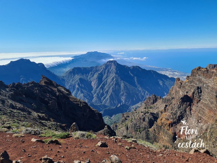
We took the section between Roque de los Muchachos to Pico de la Cruz, about 5.5 km long in each direction. The trek runs along the ridge the entire time and has quite steep descents and ascents. Not for the faint of heart. Plus, the sun burns you the whole time because you are above the clouds and there is practically no shade here. Don't forget to bring plenty of water and a snack.
You follow the whole way until incredible views to Caldera de Taburiente and the surrounding volcanoes. You have the whole of La Palma in the palm of your hand and you can see Tenerife and El Teide. In total, we spent about 8 hours here, including breaks for snacks and some selfies.
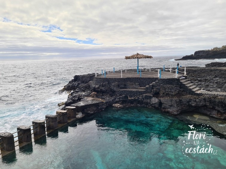
To end the day, we planned a little relaxation in Fajana Pools. It is a place in the north of the island where there are several natural swimming pools. You unroll your blanket (on the concrete, that is), stretch out in the sun and rest.
You only venture into the water once, because in April, even though it's warm and the sun is shining, the water is not a big hit and is quite cold. Speaking of pools, try this one too Charco Azul. These are a little lower, on the east side of the island and also very nice. Both with free admission.
TOUCH THE STARS
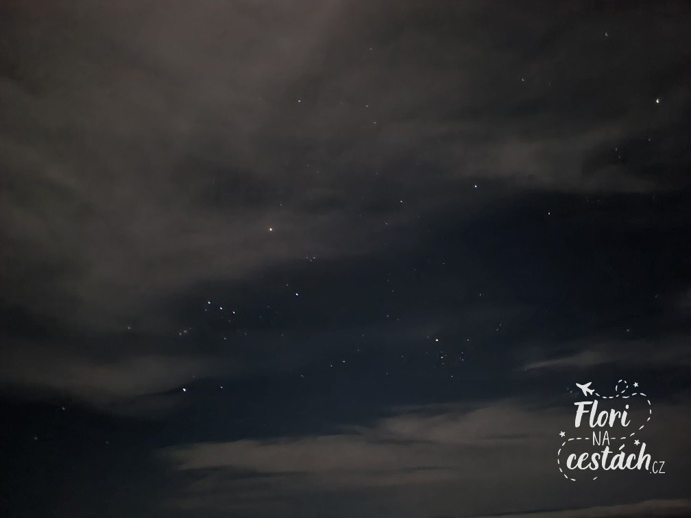
La Palma has some of the the best conditions in the world for sky observation. Go to the top of Roque de los Muchachos once more, this time at night.
Well, it was quite cold for April, after all it is almost 2,500 meters above sea level, but it was an experience.
I have never seen stars as bright as they are here. Nothing disturbs them, and the clouds are below you, so they literally cover the surrounding landscape and you suddenly you only see darkness, stars, moon. Romance like crazy.
Tilos Forest
Misty laurel forest and the star of the island of La Palma is a clear destination for your next trip to La Palma. It is located in the northern half of the island, 4 km from Los Sauces. It is ecosystem inherited from the Tertiary, which at one time became the first biosphere reserve on the island. It preserves a natural heritage of exceptional value. The road leading here ends at the visitor center, where you can learn more about the reserve (for free). Several hiking trails also start here.
We completed three routes. The first, about 2 km long, took us to a viewpoint Espigón Atravesado Lookout. The elevation gain of about 250 meters was quite a challenge. But the final view was worth it. Vast walls, dense forest and birds waiting for whatever you throw at them. The way back was downhill, so it was a quick trip.
Los Tilos Waterfall
The second route will take you to the biggest attraction here. Cascada de Los Tilos waterfall.
It's a short walk from the road, you even walk along the levada for a while and it feels a bit like Madeira. Then a tunnel and you're at the waterfall. If you want nice photos, wait... wait... wait... and if you snap it at the right angle, you can do it even without people.
The third route then starts right at the visitor center. The gentleman at the entrance said that it was track. Come on. Get ready for about a million steps, always uphill, crazy elevation. Suddenly you discover muscles you didn't know you had.
After about 2 km, you will come to a clearing, completely destroyed, where there is a gazebo, benches and view of the east coast and the ocean. You rest, have a snack, take more photos and go back the same way. Only down, so it's faster.
In Bosque de los Tilos you will experience an explosion of biodiversity and greenery. In the harmless jungle you will find abundant moss growth, silence and the fresh scent of leaves.
It is one of the few reservations misty laurel forest in the world, with lush broad-leaved trees, which were abundant all over our planet millions of years ago. That is why the Bosque de Los Tilos was declared a World Heritage Site in 2002. UNESCO biosphere reserve and today its protection extends to the entire island.
Volcanoes Route
A challenging hike among volcanoes. The total length is almost 25 km and it climbs to a height of almost 2,000 m. Its starting point is the El Pilar campsite (Refugio del Pilar), which lies in a mountain saddle where the Cumbre Nuave and Cumbre Vieja mountains meet. It then ends at the very tip of the island at the Faro Fuencaliente lighthouse.
The plan was great, the reality was different. Our goal was not to cover the entire 25 km in one direction, but we wanted to start in El Pilar. Maybe if Cumbre Vieja hadn't blown up, we would have managed it. We set off with great excitement and arrived at the roadblocks and the closed road. So nothing. But we didn't despair and the next day we tried it the other way around.
Faro Fuencaliente, Salinas de Fuencaliente
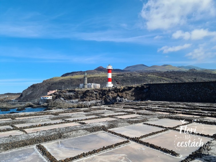
Arriving at the Faro Fuencaliente lighthouse already gives you the impression that you are approaching a slightly different planet. You feel like you are more on Mars, than in the Canary Islands.
Right next to the parking lot and the lighthouse are the Salinas de Fuencaliente. Be sure to visit them too. You will walk around lava lakes, where sea water evaporates and salt is produced. You can then buy it in the shop right next to the Michelin restaurant.
The GR 131 route begins (or ends) at the lighthouse. Here it is under the name Volcanoes Route. ...that is, the path between the volcanoes.
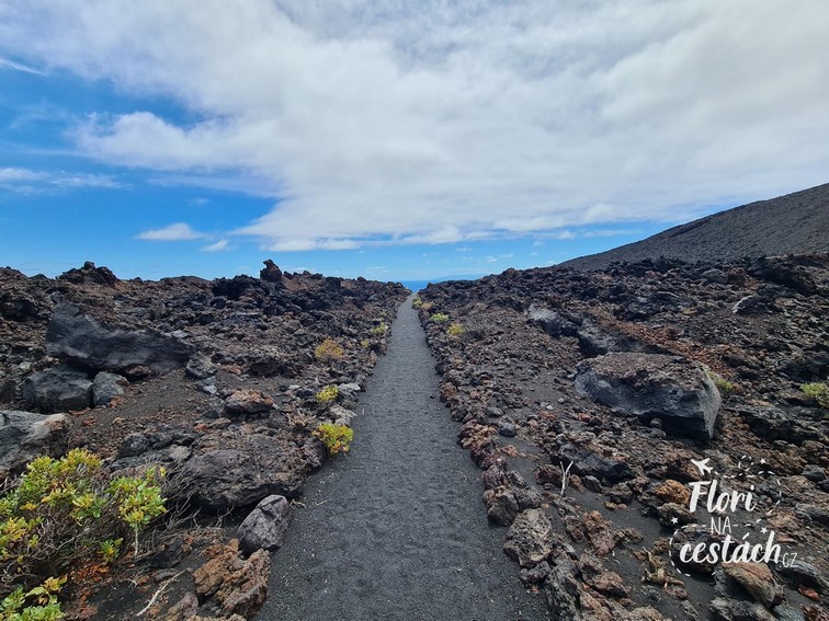
From the lighthouse you go uphill. There is nowhere to get lost. It is here path made of small lava stones, something like gravel. Then there are larger lava stones and boulders around. When the sun is shining, it gives you a hard time. There is not even a bit of shade.
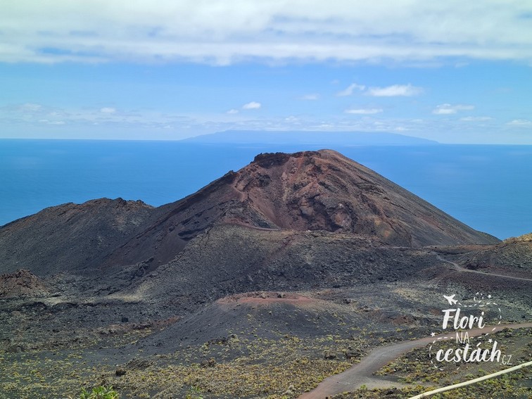
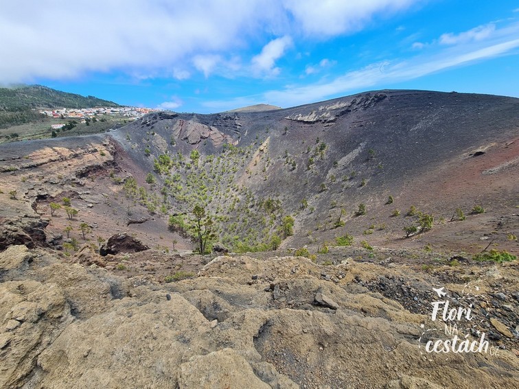
You pass by in less than an hour Teneguía Volcano. He made himself known for the last time in 1971. You can extend your route and walk all the way to it or climb the mountain and look into the crater. But when you know that you still have a few kilometers and a steep hill ahead of you, it's better not to stop.
San Antonio
Just below the San Antonio volcano, perhaps you will find steepest part. When you climb it, you will find yourself at the entrance to the visitor center. You pay 5 Euros and go take a look. The visitor center is great. If you are interested history of the Canary Islands, like how they were formed, how they are connected by volcanic channels and how they evolved, it's the holy grail for you. You'll find out everything here. And as a bonus, you can experience what it's like when everything shakes underneath you on an earthquake simulator.
The volcano itself is a few dozen meters from the visitor center. You walk along its summit to the viewpoint of the Teneguíja volcano. On the way, you look into the crater for a moment, then into the lava-strewn surroundings. You enjoy the views and then walk all the way back. It's easier again because it's downhill.
Route of the Volcanoes II.

There are never enough volcanoes and craters, so there's no choice but to go for it. another part of the route between the volcanoes. This time from Fuente de los Roques. It is a recreational area located at an altitude of more than 1,000 meters. You can get here by car and park in the parking lot. We, already familiar with guards and closed routes, preferred to park a little lower and go straight on the trek over the old lava, outside the campsite.
Actually a bit aimless, but we came to the volcano de Martin. The journey is like Martian landscape, only this time with trees and some greenery. And because at this height clouds usually pass around La Palma, we found ourselves directly inside the cloud several times, which only added to the sometimes eerie atmosphere of this area.
Martin Volcano
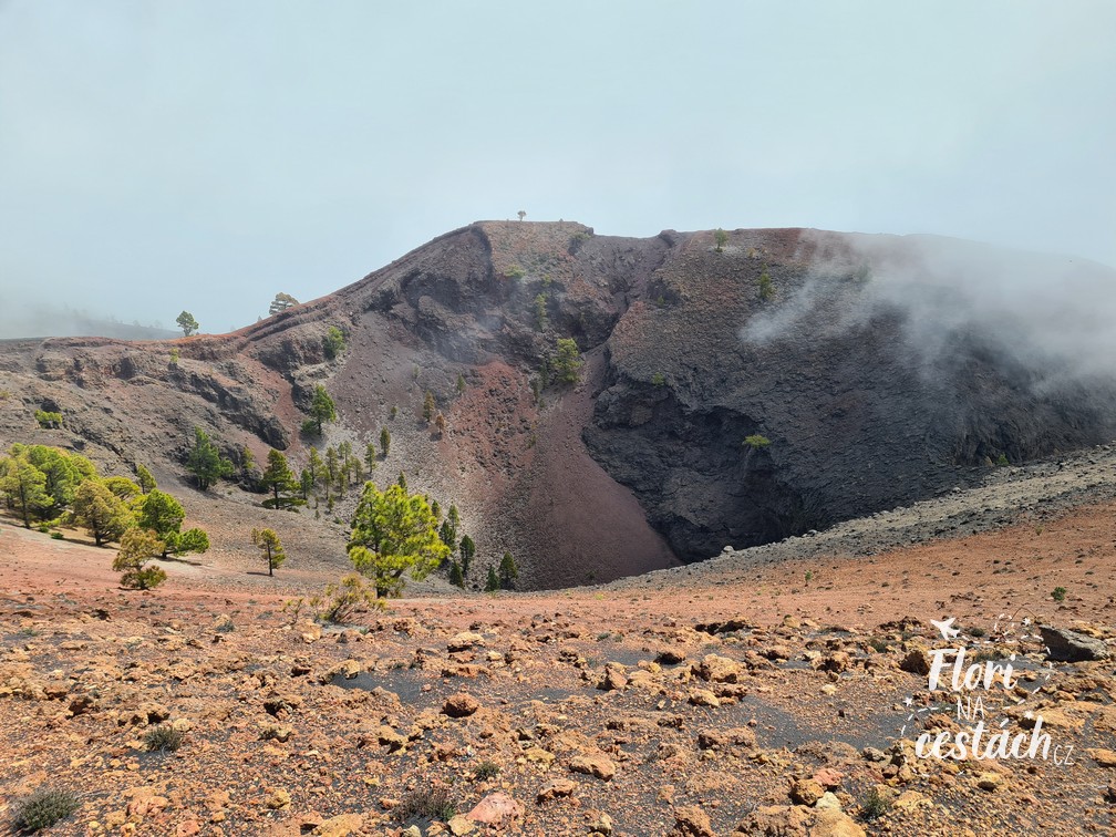
The peak of the Volcano de Martin was hidden in the clouds for some time, but as soon as the clouds parted, we could observe its characteristic colors.
Along its perimeter one color after another, it's an almost surreal sight. It's even more intense the heat rising from the volcano.
For the way back we chose the second route (at one crossroads we turned right and went more of a circuit). After a while we found ourselves in a pine forest.
Canary Island pine
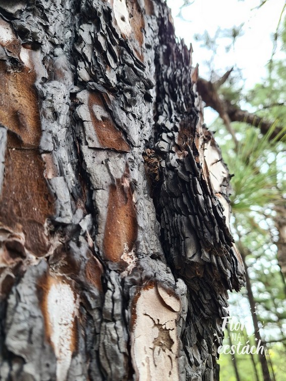
Just for fun, Canary Island Pine is fire-resistant conifer. In the ecosystem of the Canary Islands, it plays a key role in water retention. This is due to the frequent ocean fog that condenses on the long needles of this pine and then drips to the ground. This pine is found naturally only in the Canary Islands, where it grows on volcanic substrates, at altitudes of 600-2000 meters, and forms extensive, often single-species forests.
What was La Palma like?
La Palma is definitely an island that will surprise you. It will surprise you with its beauty and diversity. It is a place worth returning to. It is not for nothing that La Palma is called The Beautiful Island (beautiful island). In a week we didn't even see everything this island has to offer. If you're going here, don't just go. Plan and schedule what you want to see and plan everything carefully.